Great Divide Trail - Fire, Bears & Section B

Fire has hit the GDT in a big way. At present we are in Banff and a big chunk of section C (near Banff is closed).

We saw signs that fire season was coming all along the way. It hasn’t rained a drop since our first day (2 weeks ago) and it’s been hot, like 30C hot, on most days. Along some dirt roads the fire service has set up outposts and are just sitting and waiting for fires to break out.

GDT B-08415.jpg

We depart Coleman and start section B with the forecast calling for 7 days of sunny and hot weather. In Coleman we stayed at A Safe Haven B&B and the hosts, Alannah and Dan, are among the few trail angels on the GDT. They offer discounts to hikers and even load us up with food as we head out. We were so busy before we left we completely forgot to call and book (or even state our intentions) to stay with them. I felt pretty sheepish showing up at their door unannounced but they didn’t bat an eye and welcomed us into their home.

We end up grabbing a hitch out of town to the Dutch Creek Provincial Recreation Area. This goes against the thru hiker ethos but after reading trail reports about the section before Tornado Mountain we decide that hitching saves us a day (we are on a tight schedule). It gets us to the Dutch Creek CG in 29km vs 64km on the primary route.  

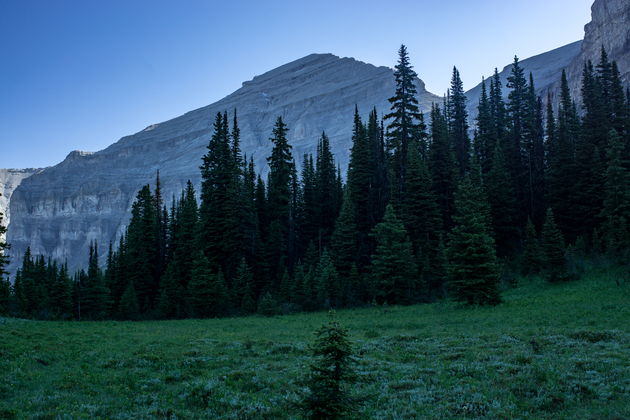
Dutch Creek Campground is a beautiful spot nestled near a boulder field just before Tornado Pass. This early in the season it’s fairly marshy and it takes a bit to find a dry site. In the night I’m awoken by the sound of rocks being tossed around in the boulder field. It’s a near a full moon and fairly light out. I don’t see anything but I do remember seeing a decent amount of bear poop on the trail up. I toss and turn for the rest of the night unable to sleep thinking about what might be flipping the rocks...

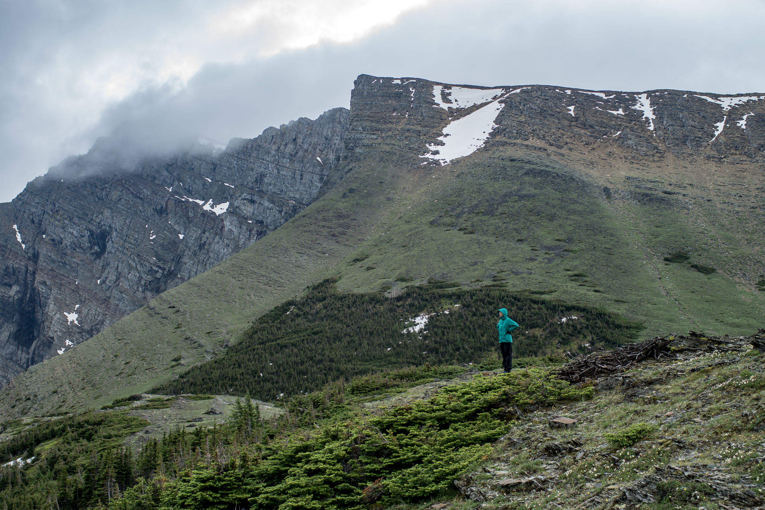
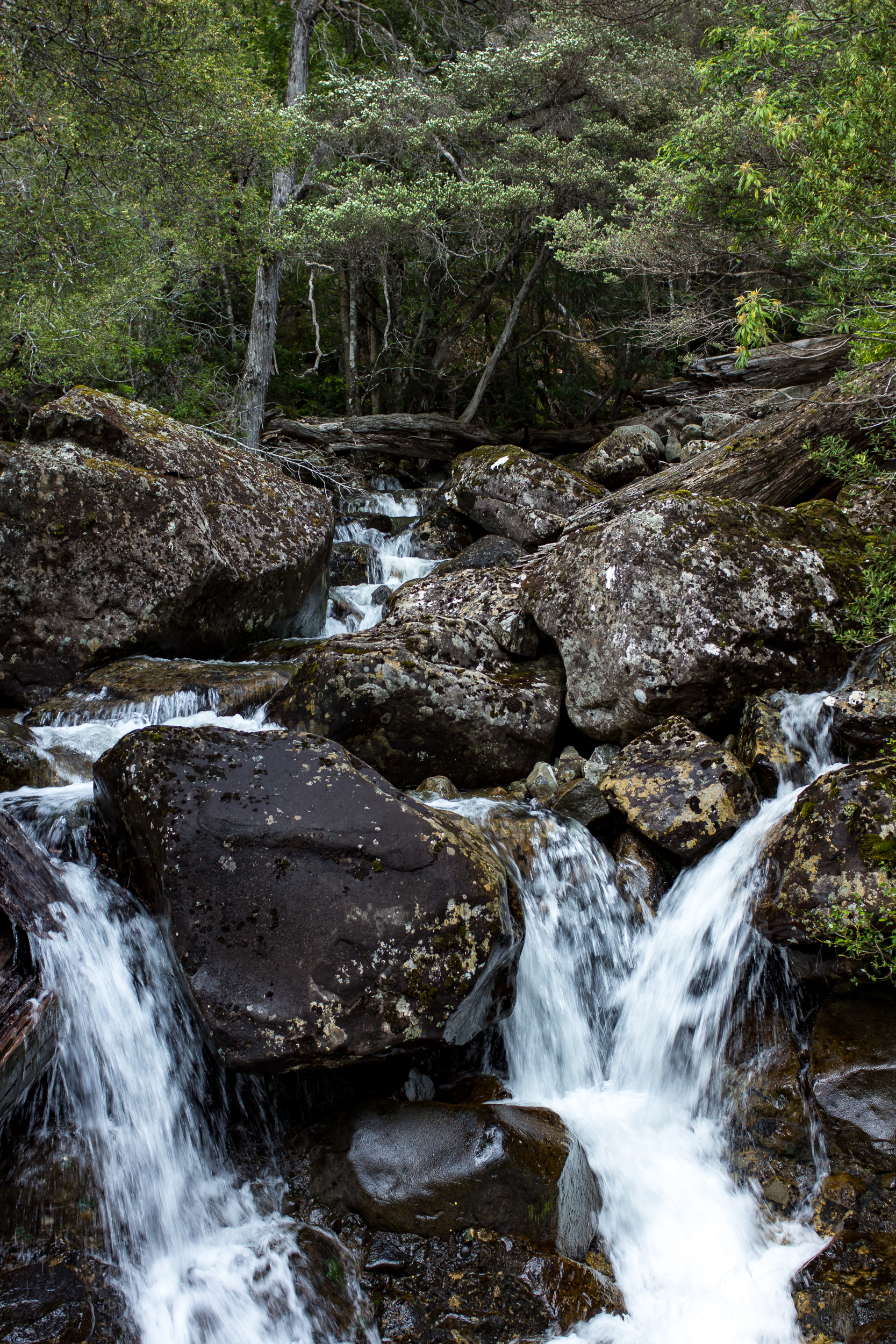
The next day we head up and over Tornado Pass, made more challenging due to an avalanche over the trail. The trail up is steep shale, definitely our hardest climb of the trail thus far.

After last night’s sleepless night I’m definitely a bit freaked to sleep out in the backcountry again. The Oldman River Road is only 3.2km off trail and there is more car camping, campgrounds etc along the road. It’s illogical to think it’s safer around car campers but it comforts me and we choose to camp along the road.

GDT B-08403.jpg
GDT B-132.jpg

The next day we hear from campers that there are fires burning in British Columbia and possibly close to the GDT itself.

Which brings us back to Banff, right now trying to figure out the game plan. Given our short window of time and that we weren’t planning on doing the whole GDT we’re torn on whether we try to keep going somehow or switch up the plan. We still have about 3 weeks before we need to head home.

For now we wait.

Great Divide Trail Section A

We begin our adventure on the GDT with a climb from Waterton to Alderson Lake, our first camp. It’s only 7.5 km (4mi) but it’s a nice way to ease into the trail.

GDT A-08173.jpg

A contentious issue before we started the trip was the matter of camp shoes. I was staunchly against, K was in favor of a pair of cheap flip flops (7 ounces, insane!). It’s day 1 and we come back from cooking dinner to a missing flip flop. We hunt for it with no luck. I’m blamed. I swear it was a marmot (it was, honest).

GDT A-08186.jpg

It rains overnight and we wake up to a misty morning. The trail to Carthew Lakes is clear until just before the last steep climb to the lake, here we encounter a ~6ish foot snow wall. We make it over by cutting in foot and hand holds and slowly making our way up. At the top we see the lake and tons of marmots hanging out on the rocks (which one of you is currently lining your burrow with a comfy stolen flip flop?). When we get to Cathrew Summit the fog has lifted and the views are jaw dropping. We are definitely take an early lunch break here.

GDT A-08191.jpg
gdt pano.jpg

At Cameron Lake the sun is shining and it’s packed. We just left Waterton yesterday but it feels weird to see this many people especially since we only saw one other camper last night. From here we head down the road to the Akamina Trail and the Akamina Creek Campground. We make it to the campground by 4pm and enjoy the rest of the sunny day relaxing near the creek.

GDT A-08202.jpg

Day 3 we head back out to the road and take it to the Tamarack Trailhead. We debated taking the Mt. Rowe-Sage Pass alt but it’s only day 3, let’s not get ahead of ourselves. The trail up is mostly shaded, good cause it’s getting warm, and the wildflowers are everywhere. About 5km (3mi) from the start of the trail we reach an open meadow before we start up the ridge. From here the ridge looks impressive, and it is, there is 1,500ft of elevation gain in the next 1.5 miles.

GDT A-08249.jpg

Walking up to the ridge we are going over snow patches, most are fine, a few are a little steep and deeper than I’d like. What makes me more nervous is the snow above us, it looks stable but it’s overhanging the edge. We hurry past this part of the bowl and just before the apex of Lineham Ridge there is one last lick of snow to cross. The ridge comes to a point and the trail goes up and over. To our left it’s steeper with deeper snow (see: slide back down the 1,500 ft we walked up), to our right a ~700ft drop off (see: death). There’s a big bear paw print in the snow, and the view past it is obstructed by a small rock pile we have to cross. From looking at either side of the snow in the small dip before the rockpile I come to the conclusion that it’s probably not a snow bridge. K really doesn’t like the “probably” qualifier. We brave it over and thankfully it’s not as bad as it looked once we get on it. Once we’re on the other side the entire ridge down is snow free with views for miles.

GDT A-08262.jpg
GDT A-08256.jpg

The Tamarack Trail follows the northeast facing side of the valley and there is still snow (and snowmelt) here making it a slow slushy walk. We come across many bear prints and fresh-ish scat on this section of trail. I’m glad Lone Lake, our destination, is in another valley.

GDT Section A-078.jpg

Day 4 and another day of clear blue skies. I didn’t get very cold last night so I’m expecting today’s going to be a hot one. We head out toward Twin Lakes, no one else in sight. The trail into Twin Lakes is the same as into Lone Lake, snow covered and some postholing is required to get down. When we get to Twin Lake we stop and have our first major trail discussion of the trip.

GDT A-08283.jpg

After yesterday's freaky snow experience on Lineham Ridge we’re not sure what the GDT primary route over Sage Pass will be like. We don’t have ice axes for snow travel and we know the next 2 days involve some very steep ridges. Could be dicey. The alternative is to take the Twin Lakes Trail down to (I think) the Avion Ridge Trail. Once the trail hits the border of the park we should be able to take an old fire road down to the South Castle River and then follow the road/ATV trails out to the road and rejoin the GDT at A31/Syncline Mountain Trail. It’s a big detour and it’s skips some great ridge walking, but much less risky.

GDT A-08325.jpg

In the end we take the detour, I’d hate to come across a situation feel “obligated” to continue on a dangerous path. It’s a bummer but the route ends up being a fun journey through the castle river valley. Once we are at the edge of the park the trail stops but the fire road is obvious the whole way down. There are a few blowdowns but nothing too intense. When the trail levels out there are sections of brushy willows bushes over the trail, annoying more than difficult, but otherwise a clear trail. We camp about ⅓ of the way down the valley.

GDT A-08380.jpg
GDT A-08319.jpg
GDT A-08375.jpg

Day 5 is mostly walking down the rest of the Castle River valley and then out to the 774 road. The walking goes fast, as we get closer to the developed road the trail changes to ATV to gravel road. We spend part of the afternoon “swimming” (more like running in and running out of the water before we freeze) in the Castle River, later we find an old campground near the river to stop for the night. The walking was easy, mentally it was tougher thinking about the ridge section we were skipping.

Day 6 We begin the day by hitting the 100km mark of the trail (although with our detour i’m not sure how far we’ve actually walked), then immediately onto a cutline straight up 1,000ft. After that we’re mostly on ATV roads for the rest of the day until we get to Willloughby Ridge and start to climb again. It’s windy and we end up camping on the east side of the ridge instead of the ridge itself to provide some shelter. The only flat-ish spot is the trail itself which is also covered with bear track (black bear I think/hope). Yikes.

Day 7 Walking Willloughby Ridge is beautiful and the weather is calm. We’re not in the mountains but the views of the mountains from here are stunning. After the ridge it’s 16km of ATV trails into Coleman. Section A complete!

Links:

Getting to the GDT

Getting to the start of the Great Divide Trail is an adventure in itself.

Fortunately for us the Amtrak runs through Wisconsin only a 20 minute drive from my parents house. We can take this to Glacier National Park and then taxi the rest of the way to the trailhead.

2017-06 GDT Start Trail-041.jpg

Before we leave Madison for my parents house we stop by K’s favorite restaurant for lunch, La Taguara. They comment on our car loaded with stuff and we mention we’re moving out of town after lunch. As we’re finishing lunch the owner drops by the table and gives us a couple desserts to go! Awww… I’m missing Madison already!

After unloading our car we get a ride to the Amtrak station. We arrive early and my parents insist that we get another lunch (I’m still stuffed from lunch #1), so when the train pulls in I roll onto the train. To add a bit of comedy to our departure  we each have a giant bag (literally a sack for lawn waste) with our food resupply for the trip. Mailing internationally to Canada is expensive and with K’s gluten allergy we can’t risk the food getting stuck in customs. Roughly 50lbs of food each will be accompanying us on the train.

2017-06 GDT Start Trail-051.jpg

The train winds up the Mississippi towards the Twin Cities and we’re treated to a sunset over the river. The next evening we arrive in East Glacier more or less on time (rare for Amtrak I’m told) and head to Brownies Hostel. Normally I’d walk the ½ mile but with our packs and 50lbs of food each we catch a cab with Rhonda of Mountain Chief Cab Company (who’s also giving us a ride to Waterton in the morning).

2017-06 GDT Start Trail-056.jpg

It’s around this time I realize that when I synced music to my phone the day before we left I also somehow wiped the digital copy of our printed maps. We still have the printed maps. We still have the Guthook app. But this doesn’t stop me from losing a decent amount of sleep over this mishap. Ehhh, anxiety my old friend.

In the morning Rhonda picks us up, right on time. Mountain Chief Cab Company is a great service to hikers, they offer to pick up and drop most anywhere, even across the border, which no one else seems to do.

Border crossing goes pretty easy, we don’t even have to get out of the car and they don’t seem to mind the ridiculous amount of food we are bringing over. Fairly anti-climatic. We get dropped off at the post office and mail our boxes. I’m happy to be rid of that food. Then we grab our permits at the ranger office for the first few nights in Waterton Lakes National Park. We see our first bear wandering through the middle of town, great…

It’s only 11am and today’s hike is only about 8km so we get in one last breakfast for good measure before hitting the trail!

GDT Prep

 
our final gear for the trail

our final gear for the trail


The last few weeks have been a hectic mix of finishing up loose ends at work, moving out of our house and prepping for the Great Divide Trail. It’s been crazy to say the least.

When K was at a conference I pulled a couple long nights prepping meals for the trip. She has a gluten allergy so it’s much easier to make food in advance. It would be tough to resupply in small towns and avoid gluten. Plus we like to eat as well balanced as possible when we’re out on the trail. So here’s to making 30 trail days of food in advance!

We were able to get a couple last conditioning hikes in at Devil’s Lake State Park, an old favorite and test out our Vargo Wood Stove and Tarptent MoTrail on a rainy night (it works!). Wish I had more time to write but only a week before we hit the trail!

2017-06 GDT Prep-6584.jpg
2017-06 GDT Prep-009.jpg
2017-06 GDT Prep-006.jpg

Goodbye Madison, Hello Colorado

Big news: we’re moving to Colorado! K accepted a position at the University of Colorado starting in August.

On one hand I’m excited - hiking, backpacking, mountains right out the door. On the other - I love Madison, our friends and my job. It wasn’t an easy decision and it’ll be bittersweet (as moving always is) but we’ve made it, so what’s next?

I’ve always been interested in doing a longer thru hike but I never really had a plan for how that’d work. I can’t remember how I came across the book “Grizzly Bears and Razor Clams” by Chris Townsend but when I was laid up with a broken ankle last year I devoured it. It got me on a kick to try to make a thru hike of some sort a reality.

With the move we have a short window of time, about 5 weeks, to try to do something longer. We don't have the time to do the Pacific Northwest Trail as Chris Townsend did, but we do have the time to try the first part of the Great Divide Trail in Canada: it goes from the US border to Jasper.

What’s drawing us to this trail is that it’s in a similar region to the PNT (at least for the start) and the remoteness. I love not seeing people for days and having to use maps to navigate. The GDT all but promises these experiences. So here we go!

CO flag.jpg
GDT.jpeg

Leech Attack on Ben Nevis

It was a cold misty morning when a group of us decided to drive up to summit Ben Nevis. The “road” where the trailhead starts can scarcely be called that. More like an overgrown logging track that is just wide enough for a 4WD vehicle. There’s not even a real place to pull off, so if another party would come in they’d likely block you in.

Just as we’re approaching the trailhead our friend who organized the trip casually mentions that this area is in fact known to have “some” leeches. Yay. But I’m told they only come out when it’s misty and wet -- great…

15 minutes in to the hike my ankles start itching. Weird, but i’ll keep walking. 10 minutes later they are really itching. I look down (I shouldn’t have looked down), there are at least a dozen leeches on each ankle. I frantically start ripping them off (the itching increases by factor of 10). I’m told not to stop as more will just get on me. Sound advice as the ground is literally MOVING with leeches. Holy. Shit. The “good” news is that if we walk fast and get out of the forest there will be no leeches on the rocky top. I walk fast.

Blog 2017-01 Ben Nevis-6235.jpg
Blog 2017-01 Ben Nevis-6237.jpg

We break through the forest line and everyone stops to remove the leeches the second we get onto the rocks and we continue the misty march to the top. There are no views but walking through the mist above the tree-line has its own eerie beauty which I quite enjoy. When we reach the top we take off our shoes, ring out our wet socks and remove a few leech stragglers.

Blog 2017-01 Ben Nevis-4499.jpg

We hang out at the top hoping for a break in the clouds but one never comes. As the mist comes and goes we get views below us and it’s surprising how high we climbed from the tree-line. Heading back down the mist get thicker and it takes a second to locate the saddle we climbed up on. Once we find our trail it’s every person for themselves as we race through the leech infested forest.

I’ve never been so happy to see the car.

If you dare to go:

Meander Falls & Split Rock Circuit

Ringing in the New Year by… surprise… hiking! Tassie is really great for day hikes and there are a lot of them within an hour or two of Launceston where our family lives.

Today we are heading to the Western Tiers to do the Meander Falls and Split Rock Circuit.

Blog 2017-01 MeanderFalls-4376.jpg
Blog 2017-01 MeanderFalls-4392.jpg

The first part of the trail to Meander Falls follows the Meander River up to the falls. The tread is rocky but easy to follow. As we went up the trees started to thin and we got peeks of the falls in the distance.

Blog 2017-01 MeanderFalls-4386.jpg

At the base of the falls there is a small pool, which if it was warmer would be nice for a swim/soak. The falls themselves are quite dramatic and much larger than I had anticipated. Cool.

Blog 2017-01 MeanderFalls-4407.jpg

The map indicates that the trail continues up to the top of the tier behind the falls but there isn’t any evidence of the track. We tried in a few places to locate the trail but with no luck. If you were determined it would be doable to get up to the top but it would be slow going as it is very steep here.

To head back via the Split Rock trail we headed down the trail we came up about ⅓ of a mile. There is a sign at the trail junction (somehow we missed it on the way up). The faint trail heads over the river which is easy to rock hop across but recent rains could change that so keep that in mind.

Blog 2017-01 MeanderFalls-4430.jpg

After crossing the river the trail heads up a scree slope. Cairns can help guide you but it’s fairly easy to see where to go (aim for the saddle at the top of the scree). There are great views from the saddle. We chose not to scramble up Meander Crag but it could make for a quick side trip.

Blog 2017-01 MeanderFalls-4454.jpg
Blog 2017-01 MeanderFalls-4444.jpg

Heading down the other side through a smaller scree field we were able to follow the cairns and pick up the trail as it entered the forest. The forest is much more lush on this side and we passed numerous small cascades and falls along the way down.

Blog 2017-01 MeanderFalls-4467.jpg
Blog 2017-01 MeanderFalls-4476.jpg

Make sure you take the longer more winding trail vs the “main” Split Rock trail to see these. The trails rejoin shortly after the falls and eventually the aptly named Split Rock is reached. The trail became less steep as we got closer to the car.

Blog 2017-01 MeanderFalls-4481.jpg

A really nice walk with a little of everything: Dry(ish) forest, falls, scree scrambling, long views and rainforest.

If you go: